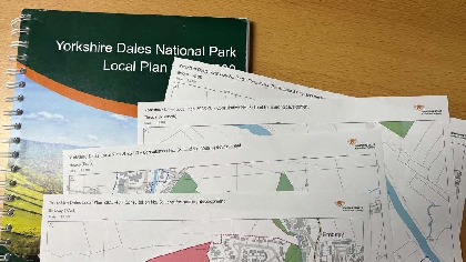
Land has been suggested for 600 new homes in the Yorkshire Dales National Park, with the details being published as part of a public consultation launched today.
A ‘call for housing development sites’ in January 2021, prompted by a need for more permanently occupied homes in the National Park to sustain local communities, resulted in over 100 sites being put forward. Initial checks on suitability have reduced this long list to 33 sites with indicative capacities ranging from between five to 100 homes.
“During the time that we’ve been working up a new Local Plan it has become clear that we need more people in permanently occupied homes in the National Park. New house building is part of the approach that will help sustain local communities and it is our role as the planning authority to make sure those new homes are built in suitable locations.
“Action on housing - particularly affordable housing - is vital for the long term viability of local communities in the National Park as it faces a significant population challenges that risks reducing demand for local services.
“Allocating a site for housing development means that planning permission for housing will be granted subject to plans meeting policies on design, affordability and such like. So this is a big moment. I want to stress that this is a consultation, not a done deal and I would urge people to share their views with us on the suitability of each of the 33 potential sites.”
Allocating housing development sites is part of the process of creating a new Local Plan for the Yorkshire Dales National Park. The new Plan will contain a set of planning policies that will shape development up to 2040.
At the moment there are already planning permissions in the National Park for around 330 new dwellings that have yet to be developed. This means that if the proposed sites are allocated, the requirement for 850 new homes in the National Park by 2040 could be met.
Additional housing will also be able to be built on smaller plots of land within housing development boundaries. Maps showing draft development boundaries have been published today and form part of the public consultation.
People are encouraged to consider the contents of the paper titled ‘Consultation No. 6 – Land for housing development’’, alongside the background evidence documents and draft maps of more 90 settlements that show where possible site allocations, development boundaries and important open spaces are proposed. The information is on the Local Plan page of the National Park Authority website.
Anyone wishing to make representations is invited to submit them by email to localplan@yorkshiredales.org.uk
Alternatively, responses can be submitted by post to Planning Policy, Yorkshire Dales National Park Authority, Yoredale, Bainbridge, Leyburn, DL8 3EL
The public consultation will close on Friday 12th May.


 Council chiefs agree record £2.5m investment in car parks
 Summer bus services in the Dales extended
 Dales pub landlady loses enforcement notice appeal
 Ex-National Park head and son pay tribute to Pennine Way in song
 A PRESSING engagement at Gallery on the Green
 Dales pavilion featured in TV advert becomes thriving hub
 Planners refuse Richmond housing development
 Wider ban on heather burning ‘risks catastrophic wildfires’
Comments
Add a comment